It has been the first El Nino in five years and it has certainly given us a pretty wild ride so far this winter. We saw near record high temperatures in December. Some around the metro saw temperatures near 70 on Christmas Day! January of course, was a cold month and got even colder when we had that Arctic Outbreak in the middle of the month. This month could be even wilder! El Nino is now transitioning to what we call a “Neutral Pattern.” Sea surface temperatures in the eastern equatorial Pacific Ocean are once again cooling from the warm waters of El Nino.
I’ve looked at the climate data when we’ve had neutral patterns in the spring and it’s not good. There are wild swings in temperatures, going from highs in the mid 40s to highs in the upper 70s, which was the case in our last “neutral” year, 2020. February, March, and April brought round after round of severe storms, many of which spawned major tornadoes. We saw a multiday outbreak in the Southeast from February 5-7, with 37 tornadoes in all, one being an EF 3 in Kings Mountain, N.C.

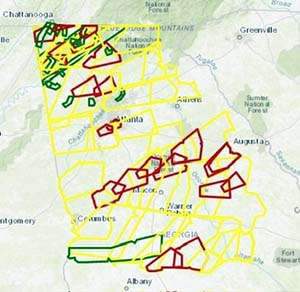
Tornadoes during the Easter outbreak of 2020.
The worst of these outbreaks occurred on April 12-13, the Easter Tornado Outbreak. I first saw indications of what was about to happen when the Storm Prediction Center outlined a strong probability of severe weather occurring from Texas, into the Florida Panhandle and on through eastern Georgia. On April 13, a tornado watch was in effect as an intense squall line approached from Alabama. An EF 1 hit Cartersville, killing one person when a tree fell on his house. Numerous tornado warnings were in effect at the same time.
The worst tornado was an EF-2 with winds between 113 to 157 mph, traveling nearly six miles through Chattooga County. Damage was catastrophic along its path.
One of the contributing factors to this was the extremely warm Gulf of Mexico. There was an abundance of energy just waiting to be tapped. And it was. The same is true right now. I would expect from here on out, we all need to be extremely weather aware. When we get into summer, neutral conditions bring higher impacts from hurricanes, which are heightened for the Florida Peninsula and Gulf of Mexico. Neutral conditions behave much like La Nina in hurricane season. We could have similar conditions to our 2005 season. Summer temperatures are also likely to be hotter than average.
Nothing is etched in granite just yet but these are the weather events that can and do, accompany a neutral year, so stay tuned!


