

A scene from the 1962 ice storm that struck the Gainesville/Lake Lanier area.
It’s just astounding to me how fast this year has flown by. Seems like not too long ago we were talking about that intense summer heat and now here we are, getting ready to end the year and charge head on into winter. This season will likely be very challenging as far as forecasting. We know we will have a strong El Nino. However, for the very first time, record high ocean temperatures may be overwhelming the already warm ocean temperatures along the eastern equatorial Pacific Ocean, changing what we would see in a normal El Nino year.
Winter officially begins on December 21st. The Winter Solstice will occur at 10:27 p.m. It happens simultaneously all over the world, yet is experienced at different times and dates because of the planet’s different time zones. The word “solstice” is derived from the Latin, meaning “sun stands still,” because the sun appears to stand still in the sky before reversing its direction.
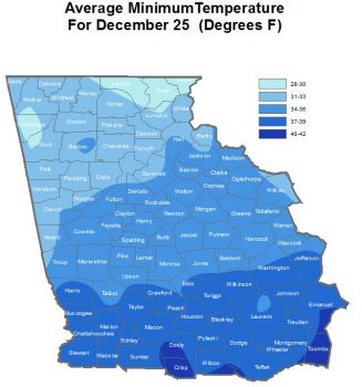
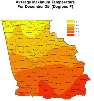
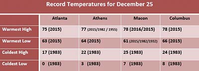
See the accompanying graphic for a look at the average high and low temperatures for the month, along with the record warmest and highest temperatures.
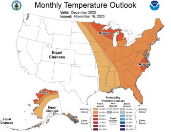
Current predictions are leaning toward above-average temperatures this month.
Let’s now talk about the elephant in the room and the question many are asking. Will there be snow or even a white Christmas?
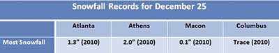
Even though some Christmases have been very cold in our area, snow on Christmas is extremely unusual. A trace of snow has only been recorded a handful of times at climate reporting sites in Georgia since record-keeping began. The most recent and significant snowfall on Christmas Day was back in 2010. In the table below are statistics regarding snowfall recorded on Christmas in our region. Precipitation began Christmas Eve, quickly changing from rain to snow across extreme north Georgia. For the rest of north and central Georgia, the changeover occurred from northwest to southeast during the day on Christmas Day as temperatures dropped to near freezing. The highest accumulations occurred in the north Georgia mountains, where anywhere between 6 and 8 inches of snow were reported, but even the Atlanta metro area saw between 1 and 3 inches – the first measurable snow on Christmas Day since 1881!
As far as other significant winter weather occurring on Christmas, an ice storm occurred in 1962 and affected parts of north and east Georgia. The Gainesville/Lake Lanier area experienced the most significant damage, with numerous trees and power lines downed and widespread power outages.
Winter is also a time when Georgia will experience severe storms and tornadoes. However, Christmas is typically quiet when it comes to severe weather. There have been tornadoes recorded in our area on Christmas Day, though. In 1964, an F2 tornado affected Crisp County in the afternoon hours, causing significant roof damage to the National Guard Armory. Furthermore, around midnight on December 26th, a strong F3 tornado affected Crawford, Jones, Baldwin, and Hancock counties. This tornado killed two people in Jones County and caused severe structural damage along its path. This episode was the most significant severe weather event recorded on or around Christmas Day in north or central Georgia.
The bottom line is we can see any and all types of weather this month. Be prepared for anything.
From my family to yours, I hope you have a wonderful holiday season.
Photo and graphics: provided by Glenn Burns.