
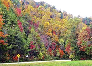
A lack of rain brings fall colors.
It has been a cold weather season for the record books! It began with an unusually long stretch of record-setting warm air this past autumn. The warmer than average temperatures, along with the lack of any significant cold fronts, led to a very quiet fall severe storm season without any “weather wars” being waged. The lack of rain gave us some spectacular fall color, which lasted a good while.
We saw a typical cool down at the beginning of December but by mid-month, the warmth came back. We were 74 degrees on December 17th!
Then, a colleague, Andrej Flis, one of the authors from the web site Severe Weather Europe, (www.severe-weather.eu), wrote to me and informed me the Arctic Ocean was unusually warm, and there was a great deal of melting arctic sea ice. He explained this melting sea ice would cause a major disruption of the Polar Vortex.
Normally, the cold air over the arctic remains bottled up and contained by a strong polar jet stream.

This winter we have had 10 Polar Vortex events!
However, sometimes it weakens and gets disrupted. This allows the frigid air over the North Pole to flow southward. This, on average, happens about once every other year. This winter, we have had 10 Polar Vortex events!
Cold arctic air was felt all the way down in the Bahamas!
I received a great deal of email saying, “so much for global warming.” However, it was the melting of the sea ice from the warming Arctic Ocean that caused the polar jet stream to begin wavering!
With the cold arctic air in place, many in north Georgia said they smelled snow! They were right. On January 10, we had our first measurable snow since 2017, with 1-4 inches falling. A week later, on January 28th, Gov. Brian Kemp declared a state of emergency for 2-5 inches of snow and ice. As it turned out, barely an inch fell. Freezing rain and ice were the culprits that stranded thousands for hour and hours on north Georgia roads.
On January 21st, records along the Gulf Coast were shattered. The first blizzard warnings in history were issued from Texas to Florida.
The Florida Panhandle saw 10-13 inches of snow. No one could believe it. Charleston, S.C. saw record breaking snow.
With winter behind us, we begin meteorological spring on March 1, with the Spring Equinox at 5:01 am on March 20th.
The Climate Prediction Center Spring Outlook is calling for above average temperatures. However, there are no clear cut signals regarding a prediction for above or below average rainfall.
I am always in favor of above average rainfall to keep the pollen at bay. But with it being spring, that sometimes means severe storms. We shall see. Happy March!
Photo: courtesy NOAA