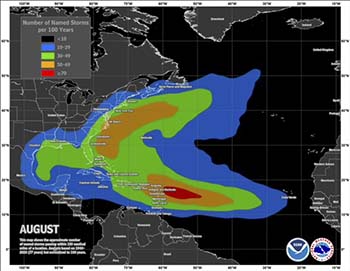
The Southeast is prone to tropical storm development.
I hope you are enjoying your summer. July was quite the weather month, as you may know. Almost daily in the national news, we saw so many temperature and rainfall records being set. Beginning in the south-central United States, through much of the Southwest, heat records that have stood for more than 250 years were shattered. Nearly 100 people have perished so far. Meanwhile, Chicago was getting hammered with long-track tornadoes. While tornado season in North Carolina is March and April, it too had long-track tornadoes in July! In the northeast, we saw unprecedented rainfall, especially in Vermont. Montpellier recorded 10 inches of rain in one day. And heavy rainfall continued for the next 10 days. The flooding was so extensive, the governor declared a state of emergency. All we heard from residents enduring the endless string of extremes was, “we’ve never seen anything like this before.”
My neighbor asked me the other day what kind of extreme weather might we see as we head into August. I’ve had my mind on just that. In July the most favored area for tropical development is the Gulf of Mexico and off the Southeast coast. This season, storms have been forming off the west coast of Africa. They usually don’t form in this area until late August or September. Climatology tells us in August the same areas are prone to tropical development with the area around the Caribbean expanding.
I have been looking at some weather extremes over the ocean. Oceanographers are measuring record-high sea surface temperatures. I also observed them. I grew up in South Florida. The warmest ocean temperatures I’ve ever seen have been in the upper 80s. While out fishing off Palm Beach recently, I saw water temperatures of 95 degrees! That’s exactly what the NOAA buoys recorded. Tropical systems feed on that kind of heat. Water tends to evaporate quicker as well. If we get a tropical system off the Gulf this month, we could see some serious rainfall. You may remember tropical storm Alberto in 1994. It brought 65 mph winds but also produced some of the worst flooding in Georgia’s history. That’s what I am most concerned about this month. I will certainly be watching.
Image: courtesy National Weather Service


