
 I have been forecasting the weather for 45 years. I’ve seen some pretty strange things in my day. However, 2022 is, without a doubt, the strangest weather year I have ever seen!
Back in mid-August, the rain was relentless and temperatures, during what should have been one of our hottest months, were some 10-degrees below average. I have a friend in South Africa. She said winter lasted three days and was followed by flooding rains. Back home, in the Pacific Northwest down through California, we saw extreme drought conditions. At the same time, we saw floods in the deserts of southern Nevada, with flooding on the Las Vegas strip. Death Valley also saw a record 1,000-year flood!
There are massive evacuations in Europe due to major flooding. The dire predictions concerning the 2022 hurricane season were never realized, at least through June, July, and August, because of the massive clouds of Sahara dust moving across the Atlantic from Africa’s west coast.
I know there are a great many climate change deniers but it’s time to wake up and smell the roses. I know our climate has always been changing but there is no doubt we are making it worse … much worse.
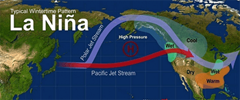
More bizarre weather is ahead as we head into winter. It’s likely that the La Niña three-peat will happen with the chance that the current La Niña will last through early winter is over 70%. If it happens, this will be only the third time with three La Niña winters in a row in our 73-year record. I know everyone gets a little more curious about winter this time of year. With a third La Niña likely, I think we can assume the weather we had last winter and the winter before, will occur this year too.
So what is La Niña and how will it affect our winter? The simple explanation is La Niña is a weather pattern that occurs in the Pacific Ocean. In this pattern, strong winds blow warm water at the ocean’s surface from South America to Indonesia. As the warm water moves west, cold water from the deep rises to the surface near the coast of South America. This colder water disrupts the “normal” wind patterns around the globe. For us in the Southeast, warmer temps are expected this winter. It should also tend to be a little drier. However, as of now, I am not convinced just yet on the drier part of the forecast.