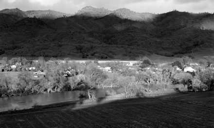
 At this time last year, Lake Lanier approached record high-water levels, topping out at 1076.10 feet above sea level in late February 2019. Fast forward to 2020 when in late February levels registered 1076.68 on February 20. The record high lake level was registered in April 1964, when the lake reached an elevation of 1077.2.
“This is the highest I’ve ever seen the levels at Lanier in all the time I’ve been here,” said the Lake Lanier Operations Project Manager Tim Rainey. “The rains just keep coming, but in the middle of February we dodged a bullet because the bulk of the predicted rainfall went farther north.”
None the less, Rainey said that from the midnight reading of levels February 5/6 to midnight February 6/7, the lake came up two feet.
At the time of publication, rainwater from the lake’s watershed had not fully moved into the lake, which could cause levels to break records.
Rainey said the Corps of Engineers is continually monitoring lake levels at Lanier and the entire Apalachicola-Chattahoochee-Flint basin downstream. “The second week of February we increased lake discharges to produce more power and did so again to increase the flow through the dam,” he said. “We will continue to release water, but so much depends on the conditions downstream.”
At the end of the summer, the Corps began drawing down water to make allowances
for expected winter rains. For more of the summer, levels hovered between 1071, which is full summer pool, and 1070, which is the target for winter pool. By early September, the levels had been reduced to just under 1068.
October saw even more water releases to bring levels to just under 1067, where the lake held until January. Winter rains that month brought the water in Lanier to 1071 by the end of January.
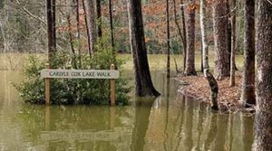
“Then the rains began in earnest,” Rainey said, “and that’s what we’re keeping an eye on at this point. We’ve closed parks and boat ramps and marinas have closed their fuel docks and cut off power and closed customer docks as necessary.”
For daily lake levels, visit https://water.sam.usace.army.mil/gage/bufelev.htm. The data is updated daily at midnight. Lakeside News also updates levels daily on its homepage, www.lakesidenews.com.