
If you’ve been waiting for north Georgia’s hillsides to put on their big fall show, you aren’t alone.
There is still plenty of green out there, even in the mountains. The calendar says autumn, but the trees have been taking their time getting the message. That does not mean the season is a bust. It means patience may be part of this year’s leaf watching. We may also get a big reward with the drier than normal weather. Fall color will likely be much more brilliant than usual. However, the color may not last as long as wetter years.
The Georgia Forestry Commission’s report described a slowly developing season, with peak color expected this month.
As we head into November, falling temperatures should become a part of the conversation. Longer nights give the ground more time to cool, and a clear, calm night can leave frost on the grass even when the nearest airport stays above freezing. Keep a jacket handy. This is the time of year when lunch outside and a chilly walk after supper can share the same day.
Of course, north Georgia has seen November do much more than bring out the sweaters. Atlanta dropped to 3 degrees on November 25, 1950, two days after Thanksgiving. That remains the city’s November record low. The cold accompanied the Great Appalachian Storm, which brought blizzard conditions elsewhere in Appalachia. Atlanta reported only a trace of snow, a reminder that bitter cold and deep snow do not always travel together.
Then there was November 2016, when drought and mountain wildfires filled the conversation, and sometimes the sky, with smoke. NASA’s Terra satellite captured thick plumes rising from the southern Appalachians on November 7. Two years later, the concern was water: Atlanta collected 7.27 inches of precipitation in November 2018. We have seen November deliver everything from cold to smoky skies and soaking rain.
That brings us to the question already coming up: What kind of winter is ahead?
A strengthening El Niño is a major player. That is the warming of the tropical Pacific that can rearrange the jet stream and influence where storms travel. You will hear this one called a “super El Niño.” NOAA is showing very strong conditions lasting through January to March. Strength matters, but it does not give us a snowfall total for north Georgia.
For our part of the country, El Niño often encourages a busy southern storm track. That can mean more opportunities for rain and, when enough cold air is available, winter weather. The moisture is only half the recipe. A storm moving across the Gulf does us little good for snow if the air over Georgia is too warm. Timing still makes all the difference.
NOAA’s Winter Weather Outlook for December through February favors a wetter South. Its temperature map gives north Georgia a modest lean toward warmer conditions, with near normal favored farther south. That is a seasonal average, not a promise of comfortable weather every week. NOAA does not issue seasonal snowfall totals in the outlook. A wet winter could mean plenty of cold rain, with occasional chances for snow or ice.
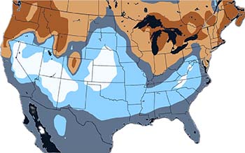
Severe Weather Europe Model shows we could see above average snow or ice.
Severe Weather Europe paints a more wintry possibility. Its analysis highlights a cooler southern U.S., an active storm track and increased snowfall potential in the Southern Appalachians. It puts emphasis on the second half of winter, especially February. Some of its main North American discussion includes March, so the comparison with NOAA’s December through February outlook is not exact.
The SWE also shows we could see above average snow or ice.
Which would I lean toward? I would say, based on past performance, the European Model and Severe Weather Europe is the one to watch. That model has had a better track record than the American GFS model. Both, however, give us a wetter signal for a lot of rain. Of course, models will get new data and will always get updated. The size of El Niño alone cannot tell us if, or when, we will see an outbreak of Arctic air and frozen precipitation. Those details become clearer closer to the storms we actually experience.
Graphic: courtesy Severe Weather Europe