
 October may be the most dramatic transition month of the year in North Georgia. Summer can still make an appearance during the opening days of the month, but by Halloween, cool nights, crisp afternoons and brilliant fall color usually leave little doubt that autumn has arrived.
Climatologically, October is also one of our drier months. Rainfall varies considerably across North Georgia because of elevation and terrain, but the long-term October average generally ranges from about 3¼ inches around Atlanta to nearly 4 inches across parts of northwest and northeast Georgia. The current 1991–2020 normal is 3.28 inches in Atlanta, 3.75 inches in Rome and 3.85 inches in Gainesville.
Of course, “average” rainfall can be misleading. Tropical systems occasionally turn an ordinarily dry October into an exceptionally wet month. Atlanta received 11.04 inches in October of 1995 from Hurricane Opal.
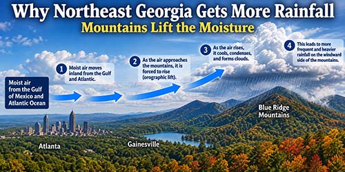
The main reason is topography, specifically the southern end of the Appalachian/Blue Ridge Mountains.
Gainesville sits near the southern edge of the Blue Ridge, where the terrain begins rising significantly northeastward into the mountains. That terrain is the major reason the climate of northeast Georgia differs from the rest of North Georgia.
Think of it this way: moisture-rich air frequently reaches Georgia from the Gulf of Mexico and Atlantic Ocean. When winds have a southerly or southeasterly component, that moist air encounters the rising terrain of northeast Georgia.
As the air is forced uphill, it expands and cools. Cooler air can’t hold as much water vapor, so clouds thicken and precipitation becomes more efficient. Meteorologists call this orographic lift.
This effect becomes even stronger farther into the mountains. Long-term Georgia climatology shows that average annual rainfall generally increases with elevation, with portions of the Blue Ridge receiving more than 60 inches per year, the wettest parts of Georgia.
That helps explain the October numbers we were just looking at. Gainesville averages about 3.85 inches in October, compared with about 3.28 inches in Atlanta. October is actually one of the drier months in the northeast Georgia mountains, but the terrain still gives the region a climatological precipitation advantage.
There’s another subtle point: Gainesville itself isn’t getting the full mountain effect. It is more of a transition zone between the Piedmont and Blue Ridge. As you travel north and northeast toward places such as Dahlonega, Helen, Clayton and the higher ridges, the orographic influence generally becomes more pronounced.
As our Super El Niño continues to develop, we will see an increasing wet pattern as the southern branch of the jet stream brings us a direct pipeline off the Pacific Ocean. I think our rainfall will increase substantially by mid-month and will continue to worsen toward month’s end. Flooding rain will be a major concern.
As far as our October temperatures are concerned, here are the average temperatures, based on the past 30 years (See accompanying graphic.)
The Climate Prediction Center believes our October temperatures will be warmer than average.
However … my friends at Severe Weather Europe are predicting near normal temperatures to below normal in south Georgia.
The best part of October is of course, the fall color. The autumn color show usually begins quietly in the highest elevations of the North Georgia mountains during early October. Shorter daylight is the primary trigger that tells trees to begin shutting down chlorophyll production. Rainfall has the biggest influence on how quickly the color develops and how brilliant it becomes. The picture on the left shows fall color in a wet pattern versus the brilliant fall color in a dry pattern.
Let’s hope for the best!