It was Monday morning, March the 7th.
I opened my iPad with my morning cup of coffee and began looking at the weather models for the upcoming 10 days. At first glance a storm was predicted to form out west and travel across the country during the week.
I took a closer look at some of the numbers and could not believe what I was seeing. The predicted pressure was 978 millibars or 28.90 inches of mercury. Is that a big deal? Well, it would be the typical barometric pressure for a CATEGORY 2 hurricane!
Usually, the initial model runs for something this large and powerful would require a few more model runs in the days ahead to see if any changes occurred and if there was any consistency. The following morning, there it was again, showing the same power. On the third day of models, no change. This was going to be epic.
I needed to know what kind of impact it was going to have on Georgia and the Southeast. For that, there is no better than the ECMWF, the European Center for Medium Range Weather Forecasts. For some reason, the European model does a much better job forecasting our weather than the American GFS, Global Forecast System model. The European model was showing a broken line of storms moving into Georgia during the overnight hours of Saturday, March 15th. When I see a line broken like that, this time of year, it means only one thing. Supercell thunderstorms. These are powerful storms where the entire storm is rotating. Winds are fierce and they are known for producing violent, long-track tornadoes, large hail, and damaging straight line winds of 60-80 mph.
I needed to find out what kind of winds would be blowing over the top of these storms. The models predicted winds at 5,000 feet to be 60-70 mph. At 10,000 feet, 70-90 mph, up higher at 15,000 feet I saw a predicted jet streak at 140 mph! These upper level winds can be brought to the ground by downdrafts and other mechanisms working within the storms.
We were still five days out and the Storm Prediction Center already had us in a risk for severe storms. It rarely does that unless confidence level is high Alabama was already in a higher risk. It was time to alert everyone to prepare for a nasty storm.

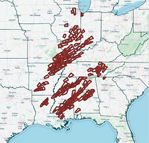
Every single red polygon was a tornado warned storm.
As it turned out, it was one for the books. It brought bitterly cold temperatures to California as it began to wind up in the West. Blizzard conditions hammered the upper Midwest. To the south, more than 130 wildfires were burning in the high winds and dry ground of Oklahoma. Dust storms blocked the sun for days in Texas along with powerful winds. As we moved into March 13th-15th, that is when the severe storms and tornadoes began erupting.
The number of severe thunderstorm warnings (yellow polygons), was staggering. The red polygons were the tornado warnings. The Storm Prediction Center issued a rare PDS (particularly dangerous situation) for violent and long-track tornadoes in Alabama.
Every single red polygon was a tornado warned storm. Two were classified at EF 4, with wind speeds of 166 to 200 mph! 42 people perished in the outbreak. Here in Georgia I was tracking one tornado that Saturday night, coming out of Alabama, heading for west Georgia. Tornado warnings were issued for Paulding and Cobb counties. A high end EF 1 left a trail of destruction.
There were no injuries in Georgia but we had a lot of frayed nerves.
The outlook for April is for continued above average temperatures with an occasional cool snap. There is no clear-cut signal for rainfall. We generally average 3.81” for the month.
Hope you all have a great April and a wonderful Easter Holiday.
Image: courtesy NOAA


