Riparian. Big word. Simple concept.
One of Mother Nature’s natural protections for wildlife, water quality and the environment is right under the noses of Lake Lanier residents, municipalities, recreational users and the public.
“Called Riparian Buffers, these are Mother Nature’s way of ensuring good water quality for fish, wildlife and humans,” said Hunter Roop, senior fisheries biologist at Georgia Department of Natural Resources Wildlife Resources Division. “The combination of dense canopy, dense undergrowth and permeable surfaces that occur naturally along streams, rivers and lakes are essential in managing water temperature, stabilizing shorelines and even providing nutrient inputs to aquatic systems.”
Lanier’s ecosystem of riparian buffers is under management of the Corps of Engineers. The public lands adjacent to that of property owners, such as residents, municipalities and marinas, plays a major role in protecting the lake.
“However, when property owners encroach on the public lands, they’re jeopardizing the natural riparian buffer,” said Tim Rainey, project operations manager with the Corps of Engineers at Lake Lanier. “These public lands are protected by federal laws and regulations. Unauthorized cutting or removal of any vegetation on public lands, is against the law. The Corps of Engineers at Lake Lanier will be increasing monitoring, detection, and enforcement of these activities and will work with the U.S. Attorney’s office, if necessary, for criminal prosecution of these offenses.”
Roop said that the laws, which also include those enforceable by the Environmental Protection Division of the Georgia Department of Natural Resources, are “here to stay.”
“Already, requirements from local issuing authorities such as the installation of silt fencing when during land-disturbing activities for construction or development are being enforced to comply with state water quality standards,” Roop said. “The governance of storm-water runoff, the proper use of culverts, and other related issues – including protection of riparian buffers – protects our state’s water resources.”
How it works; economic and environmental consequences
Natural growth along a body of water serves many purposes. From helping reduce erosion and siltation, it also slows down the water flow and allows increased absorption into ground and below-ground aquifers.
“From the leaves on the trees lessening the intensity of the rain to the root systems of trees and plants using the water, a forested buffer is ideal,” Roop said. “In addition to addressing erosion, a riparian buffer protects wildlife.

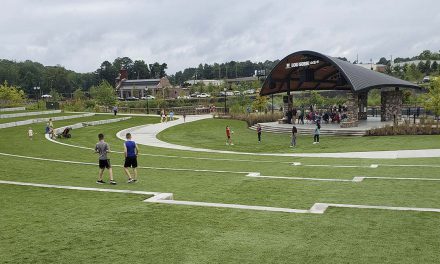
What the riparian buffer should look like except for the grading/clearing that has just begun.
As a senior fisheries biologist, Roop is keenly attuned to the damage done to fish by reduced water quality caused by run-off.
“As the water crosses an area without a suitable buffer, it often rises in temperature and sediment load, threatening conditions needed for fish to breed and spawn,” he said. “This is especially noticeable in the case of streams, but then multiply this same action by all the places along the shoreline of Lake Lanier where the riparian buffer no longer exists. Yes, the temperature increase can become even more critical.”
He explained that fish need clean, oxygenated water to breed. “In my professional focus, the real threat of degraded water quality is the decline of the fish populations in Lake Lanier.”
As for the human consequences, he pointed out that increased erosion and siltation can threaten the stability of docks, rip-rap installations and bulkheads.
“Because Lake Lanier supplies drinking water to local municipalities, poorer water quality for the lake also equates to higher costs to process water for human consumption, and Lake Lanier provides water to millions of people,” he said. “This increased cost will be passed on to consumers. It’s another economic factor that should get people’s attention.”
Dale Caldwell, director of the Headwaters Office of the Chattahoochee Riverkeeper, concurs.
“While the Riverkeeper is a watchdog organization that monitors lakes and streams for water quality and works to protect this precious resource, it is incumbent on citizens to understand these issues and their implications,” he said. “The headwaters of the Chattahoochee here in Northeast Georgia have a direct effect on what’s happening at Lake Lanier and all the way downstream. Increased sedimentation and erosion here takes its toll throughout the Chattahoochee. Lake Lanier is not operating in a bubble.”
His advice? Be aware of the laws and regulations already in place and abide by them.
Do your part, even in a small way, to support the regulations.
“It’s in the best interest of our lives and the lives of future generations,” he says. “This is not a political issue, and when the environment, particularly our water resources, are at stake, it becomes every single person’s responsibility. Millions of people depend on Lake Lanier for their drinking water.
“Many people have a waterfront residence as a second home, whether on Lake Lanier or one of the state’s many streams and rivers,” Caldwell said. “What is hard to understand is that if they’re trying to escape development or enjoy the beauty of nature, why would they want to alter this natural setting? And even more puzzling is why people who enjoy resources such as Lake Lanier intentionally destroy the ecosystem that protects water quality?”
Authority to enforce
Lake Lanier was created by an Act of Congress and as such, is subject to federal laws and regulations. The U.S. Army Corps of Engineers is authorized to manage various resources and enforce these laws and regulations related to these resources.
“It is incumbent for us as the Corps of Engineers to do our jobs of protecting these resources and the environment,” Rainey said. “We would much rather work with property owners adjacent to public lands than become adversaries. However, if enforcement becomes necessary, we will take action.”
Within the Georgia Department of Natural Resources, the Environmental Protection Division administers and enforces Georgia’s environmental laws, including implementation of several major federal environmental programs in Georgia.
What can the public do?
One of the best ways to help improve the riparian buffer around Lanier is for residents to plant native species on their own property adjacent to the public lands.
Native species on private land adjacent to public lands can further widen the riparian buffer while creating a more pleasing landscape.
“The Corps’ Shoreline Management Plan addresses these issues and includes a list of accepted native species of trees, shrubs and other plant materials that can be planted on public lands,” Rainey said. “Additionally, the Corps will allow certain actions – including removing downed or damaged trees and certain plantings on public lands – with case-by-case permission. In many cases, it will require a site visit by a ranger, but at the very least we require that property owners file written requests for these types of modifications on public lands and receive written approval before proceeding.”
Search these websites for more information about riparian buffers:
- Georgia Environmental Protection Division: www.epd.georgia.gov.
- Riverkeepers has a schematic that captures the importance of riparian zones: www.chattahoochee.org.
Additionally, visit the following websites:
- Georgia Department of Community Affairs: www.dca.ga.gov.
- USDA Natural Resources Conservation Service: www.nrcs.usda.gov.
Photos: courtesy Corps of Engineers
What is a riparian buffer?
Source: US Department of Agriculture website
Timber Trespass: Clarification of Rules on Public Lands
Many people who live adjacent to the public lands surrounding Lake Lanier may have misconceptions about the U.S. Army Corps of Engineers’ policies involving vegetation modification and tree removal. Some of this comes from residents who have lived at another Corps’ lakes and think that the rules are the same here, or they fail to fully read and understand the conditions on the Shoreline Use Permit applications they sign during change of ownership or reissue.
To be clear, the Corps does not allow any removal, limbing, or underbrushing of any vegetation on public property unless permitted under special circumstances. The determination of special circumstances must be made by a ranger, who during a site visit, determines that a tree or other vegetation is a threat to safety or property. In this case, a written permit is issued to allow removal, modification or underbrushing. This is called a Shoreline Use Permit and must be approved by the Operations Project Manager.
Other issues that require Shoreline Use Permits include any type of work or installation of facilities on public lands. These items are prohibited: clearing trees or understory vegetation, planting of non-native plants or ornamental vegetation, grading or land-disturbing activities, or placing items such as swings, picnic tables, benches, storage sheds or boat trailers on public lands.
Lake Lanier rangers discover an average of three to four major timber trespasses, the deforestation of public lands, each year, typically during dock permit inspections or renewals. Additionally, rangers identify between seven and 10 other issues that fall into this category, such as unpermitted underbrushing or removal of limbs. Add that to areas that were previously cut and have failed to re-establish naturally, and the number grows to five to 10 per month.
Penalties for violating these rules can run upwards of tens of thousands of dollars in fines because of damage to public lands. Title 36 Code of Federal Regulations Section 327 also allows for the issuance of a citation. The regulations require that the area affected be restored; the number of trees to be replanted depends on the number and sizes of trees removed. Fines are determined by rangers who use a nationally recognized tree-appraisal formula that takes into account the tree size, the location and the condition of the tree.
The area will also be designated as a “restoration area” and flagged with two yellow markers, one facing the lake and the other on the property line facing the residence. The Corps may also file a Notice of Encroachment with the permittee’s county of residence. The property owner may be required to remove their dock until the matter is appropriately resolved.
For questions about Shoreline Use regulations, please call the Lanier Project Office at 770-965-9531.
Written by Corbin Martin, Park Ranger
This column first appeared in Lakeside News in 2016.